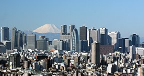
Tokyo
Gamal
Tokyo
東京都 | |
|---|---|
| Tokyo Metropolis | |
| Nickname(s): | |
| Anthem: "Tokyo Metropolitan Song" (東京都歌, Tōkyō-to Ka) | |
<mapframe>: The JSON content is not valid GeoJSON+simplestyle. The list below shows all attempts to interpret it according to the JSON Schema. Not all are errors.
Interactive map outlining Tokyo | |
 Location within Japan | |
| Coordinates: 35°41′23″N 139°41′32″E / 35.68972°N 139.69222°E | |
| Country | Japan |
| Region | Kantō |
| Island | Honshu |
| Capital | Tokyo (de facto; de jure: Shinjuku)[2] |
| Divisions | 23 special wards, 26 cities, 1 district, and 4 subprefectures |
| Government | |
| • Body | Tokyo Metropolitan Government |
| • Governor | Yuriko Koike (indp.) |
| • Representatives | 42 |
| • Councilors | 11 |
| Pemesai | |
| • Total | 2,194 km2 (847 sq mi) |
| • Metro | 13,452 km2 (5,194 sq mi) |
| • Rank | 45th in Japan |
| Highest elevation | 2,017 m (6,617 ft) |
| Lowest elevation | 0 m (0 ft) |
| Penyampau mensia (2024)[5] | |
| • Total | 14,187,176 |
| • Rank | 1st in Japan |
| • Pemadat | 6,363/km2 (16,480/sq mi) |
| • Urban | 39,105,000 |
| • Metro | 41,000,000 |
| • Metro density | 3,000/km2 (7,900/sq mi) |
| • Dialects | |
| Demonym | Tokyoite |
| GDP[7] | |
| • Total | JP¥109.692 trillion (US$1.027 trillion) (2020) |
| • Metro | JP¥222.129 trillion (US$2.084 trillion) (2020) |
| Time zone | UTC+09:00 (Japan Standard Time) |
| ISO 3166-2 | JP-13 |
| Flower | Yoshino cherry |
| Tree | Ginkgo |
| Bird | Black-headed gull |
| Website | www.metro.tokyo.lg.jp |
Tokyo (Templat:Lang-ja, Tōkyō), nama resmi iya Metropolis Tokyo (Templat:Lang-ja, Tōkyō-to), nya indu menua Jipun enggau siti ari mengeri ke pemadu mayuh mensia di dunya, enggau penyampau tubuh lebih 14 juta peranak naka taun 2023 sereta indu nengeri kedua pemadu mayuh mensia di dunya.[8] Kandang Menua Tokyo Besai, ke nyengkaum Tokyo enggau sebagi ari enam prefecture ke besemak, nyadi kandang menua metropolitan ke pemadu mayuh mensia di dunya, enggau 41 juta iku peranak naka taun 2024.
Malin
[edit | edit bunsu]- ↑ "Japan opens up to foreign direct investors". February 12, 2018. Diarkib ari asal ba February 16, 2024. Diambi February 16, 2024.
- ↑ 東京都の県庁(都庁)所在地について ("On the seat of the prefectural government (Metropolitan government) of Tokyo Metropolis"). Tokyo Metropolitan Government. Diarkib ari asal ba February 12, 2024. Diambi May 11, 2024. The special ward of Shinjuku is the seat of the Tokyo Metropolitan Government. Tokyo as defined in this articles is a prefecture, not a municipality, Tokyo's special wards, cities, towns and villages are Tokyo's municipalities. As the informal prefectural capital of Tokyo, "Tokyo" means the 23 special wards of Tokyo, i.e. former Tokyo City, not Tokyo, the entire prefecture/"Metropolis" as defined in this article.
- ↑ "Reiwa 1 nationwide prefectures, cities and towns area statistics (October 1)" (id jaku Jepun). Geospatial Information Authority of Japan. December 26, 2019. Diarkib ari asal on April 15, 2020. Diambi April 28, 2020.
- ↑ "Mountains of Tokyo Metropolis" (id jaku Jepun). Geospatial Information Authority of Japan. Diambi April 28, 2020.
- ↑ "東京都の人口(推計)とは" [Population of Tokyo(estimate)]. www.toukei.metro.tokyo.lg.jp (id jaku Jepun). Diarkib ari asal ba June 9, 2023. Diambi September 10, 2024.
- ↑ "Major Agglomerations of the World". Population Statistics and Maps. February 28, 2023. Diarkib ari asal ba July 7, 2023. Diambi September 10, 2024.
- ↑ "県民経済計算(平成23年度 - 令和2年度)(2008SNA、平成27年基準計数)<47都道府県、4政令指定都市分>". esri.cao.go.jp. Diarkib ari asal ba January 23, 2024. Diambi October 8, 2023.
- ↑ "Major Agglomerations of the World". Population Statistics and Maps. February 28, 2023. Diarkib ari asal ba July 7, 2023. Diambi August 31, 2022.
Kategori:
- Laman dengan argumen formatnum bukan angka
- Artikels with short description
- Short description with empty Wikidata description
- Articles containing Jipun-language text
- Articles containing Japanese-language text
- Pages using multiple image with auto scaled images
- Coordinates not on Wikidata
- CS1 uses Jepun-language script (ja)
- CS1 Jepun-language sources (ja)
- Pages with broken maps


