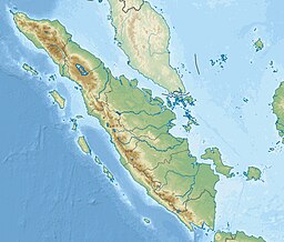
Selat Bangka
Gamal
| Selat Bangka | |
|---|---|
 Selat Bangka enggau Pulau Bangka | |
| Coordinates | 2°34′S 105°46′E / 2.567°S 105.767°E |
| Type | strait |
| Basin countries | Indonesia |
| Max. length | 134 batus (216 km) |
| Min. width | 9 batus (14 km) |
| Max. depth | 90 kaki (27 m) |
| References | Selat Bangka: Indonesia National Geospatial-Intelligence Agency, Bethesda, MD, USA |
Selat Bangka nya selat ke nyerara pulau Sumatera ari Pulau Bangka ba Tasik Jawa, Indonesia. Pemanjai selat tu dalam urung 134 batu (216 km), enggau libar dalam urung 30 batu (48 km) nyentukka 9 batu (14 km).[1]
Malin
[edit | edit bunsu]- ↑ Schauensee, Rodolphe Meyer de (1958). "The Birds of the Island of Bangka, Indonesia". Proceedings of the Academy of Natural Sciences of Philadelphia. 110: 279–299. JSTOR 4064532. Retrieved 24 March 2022.
Kategori:
- Pages using the JsonConfig extension
- Artikels with short description
- Short description is different from Wikidata
- Pages using infobox body of water with auto short description
- Coordinates on Wikidata
- Articles using infobox body of water without alt
- Articles using infobox body of water without pushpin map alt
- Articles using infobox body of water without image bathymetry

