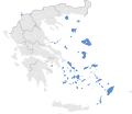
Fail:Location map of AegeanIslands (Greece).svg
Gamal

Saiz pratonton PNG bagi fail SVG ini: 693 × 599 piksel . Resolusyen bukai: 278 × 240 piksel | 555 × 480 piksel | 888 × 768 piksel | 1,184 × 1,024 piksel | 2,369 × 2,048 piksel | 8,460 × 7,315 piksel.
Fail asal (Fail SVG, ukuran dasar 8,460 × 7,315 piksel, saiz fail: 1.87 MB)
Sejarah fail
Klik ba hari bulan/maya kena meda gamal fail nya maya nya.
| Hari bulan / Maya | Gambar mit | Dimensyen | Orang ngena | Komen | |
|---|---|---|---|---|---|
| baru | 14:10, 18 Julai 2021 |  | 8,460 × 7,315 (1.87 MB) | SilentResident | Correcting Euboea and Crete, which for some strange reason I missed marking them as Aegean Islands even though they are. |
| 11:22, 21 Ogos 2018 |  | 8,460 × 7,315 (1.83 MB) | SilentResident | Reverted to version as of 17:09, 17 January 2015 (UTC) The islands are part of geographical Aegean Sea nevertheless. | |
| 19:28, 25 Mac 2016 |  | 8,460 × 7,315 (1.37 MB) | Nikospag | Thasos and Sporades are not part of Aegean Islands region | |
| 01:09, 18 Januari 2015 |  | 8,460 × 7,315 (1.83 MB) | SilentResident | {{Information |Description ={{en|1=The location of Greek Aegean Islands within Greece.}} |Source ={{own}} |Author =SilentResident,Philly boy92 |Date =2014-01-17 |Permission... |
Guna fail
Laman berikut menggunakan fail ini:
Guna fail global
Fail tu dikena mega wiki-wiki tu:
- Guna ba ar.wikipedia.org
- Guna ba el.wikipedia.org
- Guna ba en.wikipedia.org
- Guna ba eu.wikipedia.org
- Guna ba fi.wikipedia.org
- Guna ba fr.wikipedia.org
- Guna ba hi.wikipedia.org
- Guna ba hyw.wikipedia.org
- Guna ba ml.wikipedia.org
- Guna ba ms.wikipedia.org
- Guna ba sr.wikipedia.org
- Guna ba ta.wikipedia.org
- Guna ba th.wikipedia.org
- Guna ba www.wikidata.org
